July 10, 2024
Day 2: Riverton to Thermopolis
Today I could have stayed on the highway all day but I chose to start on a 21 mile unpaved rail trail. My reasoning was that the trail is shorter and flatter than the highway, and it will be a serene experience because it's across the river from the highway. Those assumptions are correct, but the trail was much more difficult than I expected.

| Heart | 1 | Comment | 0 | Link |
20 miles of the trail is unpaved. And most of that is with very deep loose gravel. I probably pushed the bike 4 of the 20 miles. Even that was extremely hard work, with every footstep sinking into the gravel, pushing a bike with the tires sinking into the gravel. When the gravel was firm enough for me to ride, I had to pedal extremely hard just to go 5-6 mph.
Today I learned that Wyoming gravel is very different from Pacific Northwest gravel which is angular basalt that packs well and doesn't roll. The Wyoming gravel is sedimentary rocks that are very rounded. It doesn't pack well, and the rocks naturally want to move and roll. Tires don't sink into Pacific Northwest gravel-it's just a rough ride. But tires and feet sink quite deep into this gravel.

After 3 miles of slow difficult gravel I crossed the main highlight of the trail, a bridge across the Wind river. It's quite impressive. Built in New York, shipped by rail in pieces, and assembled on site.

| Heart | 2 | Comment | 0 | Link |
The trail also has a smaller truss bridge and several low trestles that cross washes. All of the bridges have wooden decking that is old, rotten, warped, with occasional missing boards.

| Heart | 2 | Comment | 3 | Link |
8 months ago
8 months ago
8 months ago
Near the bridge I spoke to a farmer who passed me on an ATV. He seemed incredulous that I intended to pedal the entire length of the trail. I saw a couple more farmers but I never saw another cyclist on the trail.

Farmers drive small All Terrain Vehicles on the trail to access their fields. The gravel was always deepest in the areas where farmers access their fields. Apparently they add gravel during the spring melt to prevent making deep ruts. I have seen quite a few rail trails, and this was my first time to see a rail trail that prohibits motor vehicles, but is used by local farmers who drive motor vehicles, with them adding pretty much anything they want to the trail surface.

| Heart | 0 | Comment | 0 | Link |
The trail has several low trestles that cross drainage washes. I had to wander to try to stay on the best boards. Riding on the boards was faster and easier than riding on the gravel.

| Heart | 4 | Comment | 0 | Link |
Occasional sections of the trail are in cuts where I had the luxury of pedaling on a hard surface that more resembles Pacific Northwest gravel. But there were also sandy washouts where I had to push the bike with great difficulty. It's nearly impossible to push the bike through deep sand and not get sand on the chain. Sand goes airborne with every footstep.

| Heart | 0 | Comment | 0 | Link |
I started on the trail in Riverton at 8:15 and arrived in the village of Shoshoni at 12:15. It took me four hours to go 22 miles, 20 of it unpaved. Four hours of very strenuous pedaling and walking.
I was also delayed on the trail to mend a flat rear tire. I swapped the tube to save time sitting in the hot sun. I never did find an object in the tire. In the evening I patched a tiny hole in the tube.

| Heart | 0 | Comment | 0 | Link |
In Shoshoni I bought a burrito at the store, but just couldn't eat it. My stomach was upset from the extreme exertion. I was able to eat it 1.5 hours later after a rest and some easy pedaling.

There's nothing like a gravel trail to help me appreciate good pavement. So far the roads have had good quality and clean pavement, with a wide shoulder.

| Heart | 2 | Comment | 0 | Link |
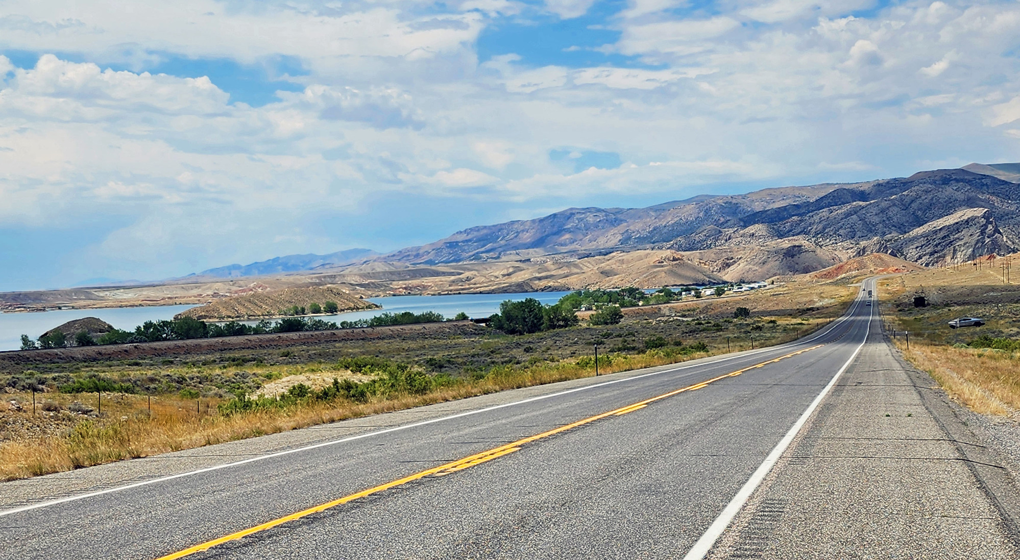
The route from Shoshoni to Wind River canyon is kind of a long slow burn, with an unobstructed view of the mountains getting gradually closer. I'm trending downstream but the route is actually quite hilly. Partly because the highway climbs high above the river to go around a reservoir.

Clouds were building as I approached the canyon. I've been in this region before, so I know the cloud pattern is the opposite of what seems normal to me. The Pacific Northwest tends to have cloudy mornings and sunny afternoons. The Rocky Mountain region tends to have sunny mornings and cloudy afternoons.
| Heart | 1 | Comment | 2 | Link |
8 months ago
Most of the country has the pattern that you are familiar with. Mornings are clear, and clouds gradually form as heat builds in the atmosphere. The chance of rain is much higher in the afternoon than in the morning.
It's helpful for a bike tourist to understand those patterns. An early start is more helpful in your part of the country than in my part of the country.
8 months ago

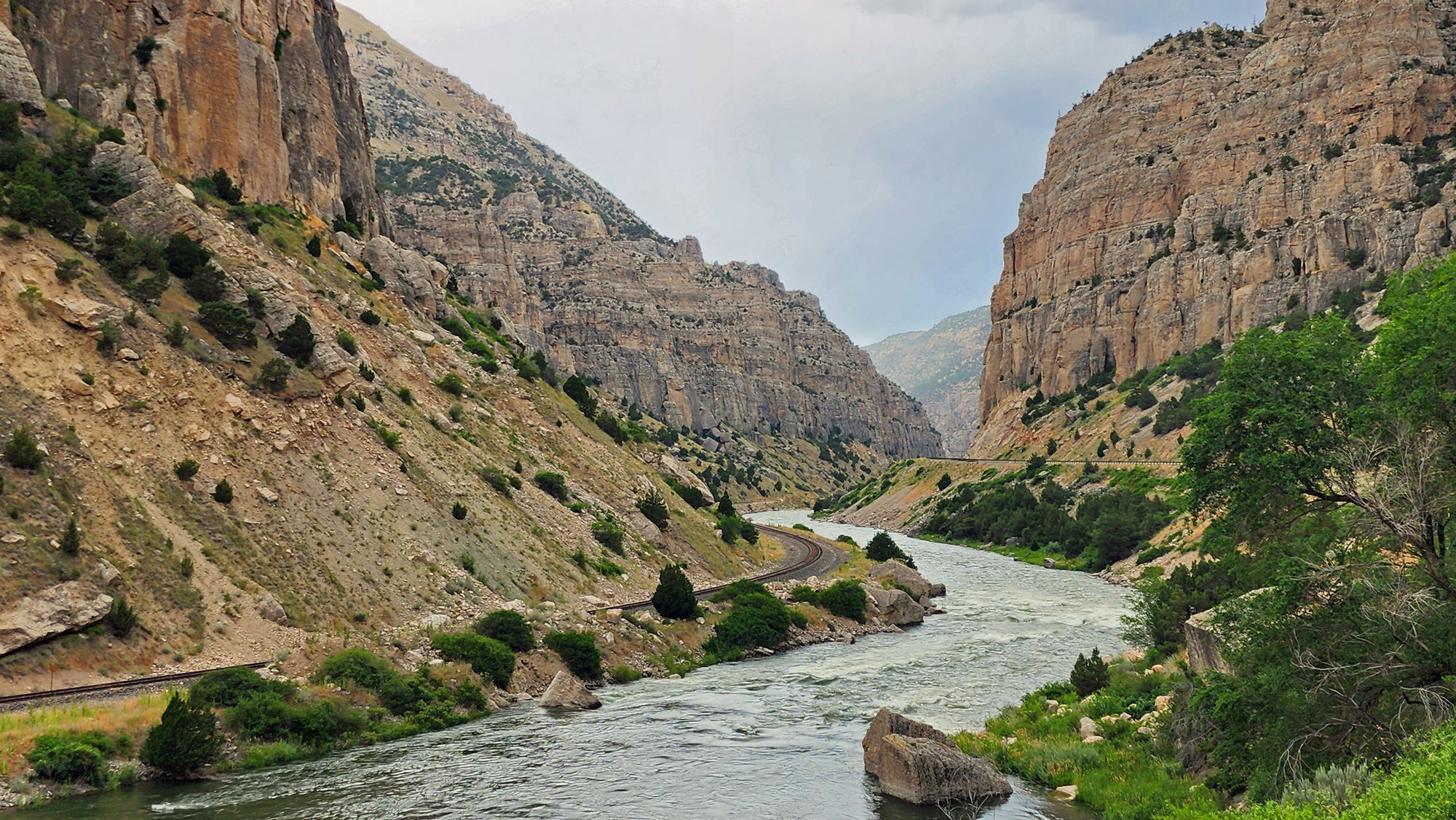
I have wanted to pedal the Wind River canyon ever since I first drove through the canyon in 2015 on the way home from my Empty Middle bike tour.

| Heart | 3 | Comment | 0 | Link |
The upstream mouth of the canyon is very narrow, requiring 3 short road tunnels and 1 railroad tunnel. The road stays on the east bank and the railroad stays on the west bank. There are no bridges in the canyon, except small bridges that cross side streams.

| Heart | 4 | Comment | 0 | Link |
I stopped to rest at a picnic area with shade. The temperature was 95F in deep shade. But clouds were building, threatening to rain.

A couple miles later it did start to rain, with a very strong headwind. I stopped at another picnic area to wait out the squall. I got back on the road after the wind died down and the rain nearly stopped, enjoying the fact that the temperature dropped to 82F. But the temperature steadily climbed afterwards, back to 95F by the time I arrived in Thermopolis.

The highway has outstanding river and canyon views in the southbound lane, but not so good in my northbound lane. To have the best view I pedaled 5 miles on the shoulder on the wrong side of the road. It seemed safe to me. I was a wrong way cyclist, but in a separate lane 4 feet outside the fog line and 3 feet outside the rumble strip. I don't regret it because it was probably the best experience of the entire tour.

| Heart | 4 | Comment | 1 | Link |
8 months ago


All good things must come to an end. I was sad to leave the canyon, but also ready to get to Thermopolis because I'm tired and hungry.

| Heart | 1 | Comment | 0 | Link |

| Heart | 0 | Comment | 0 | Link |

| Heart | 2 | Comment | 0 | Link |
I arrived in Thermopolis at 6 PM. It was a very long and strenuous day, with 20 miles unpaved. I was thoroughly exhausted but somewhat mentally perked up because Thermopolis is an interesting place to visit.
Home for the next two nights is Hot Springs Hotel in Hot Springs State Park which is across the river from the town of Thermopolis. Tomorrow is a rest/tourist day. I had dinner at the hotel restaurant and had an evening soak in the hotel's sulfury hot spring pool.
Distance: 57.1 miles total, 20 miles unpaved
Average Speed: 8.6 mph
Ascent/Descent: +944/-1394 ft.
Today's ride: 57 miles (92 km)
Total: 140 miles (225 km)
| Rate this entry's writing | Heart | 4 |
| Comment on this entry | Comment | 0 |