July 4, 2024
Day Twenty: Lyman, Wyoming to Rock Springs, Wyoming
It was another cold morning. I decided I wasn't in a big hurry to go outside. It was almost 8:30 when I finally rode out, wearing my rain jacket again. Before getting on today's route I rode downtown to look around and take a few photos. I stopped at the smallest, oldest Maverik store I've ever seen ("They won't spend the money to build us a new one", the young employee last night told me when I purchased my chocolate milk.)

| Heart | 2 | Comment | 2 | Link |


| Heart | 5 | Comment | 1 | Link |
I rode out of town on a lightly traveled pave road.

I noticed a bike path to my right, and even though the road was quite rideable, I felt my usual compulsion to ride the path., and dutifully got on it. The path only lasted a mile or so. It seemed pointless to a road/touring cyclist like me, but I suppose it's useful for local people, especially children.

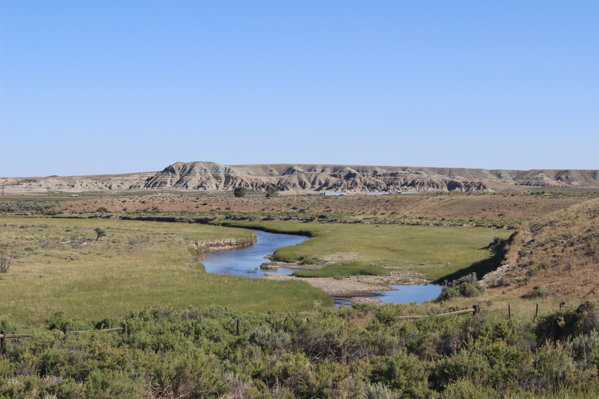
After a while I got on the first unpaved road of the day. It was high quality packed dirt. Practically as good as pavement. Zero traffic.


| Heart | 2 | Comment | 0 | Link |


I stopped at an interesting old bridge and examined it for a while.


Around this time I saw a pickup truck approaching. When I got closer, I could see that it was stopped on the road, so I stopped too. It was a local middle aged rancher. His first question: "Are you lost?"
I laughed, and told him I that didn't think so, but wasn't 100% sure. He reassured me that road we were on would eventually lead where I hoped it would. He was interested in my trip, asked if I needed food or anything else, and told me that he'd once met a man on the road who was operating a horse-drawn wagon from Boston.
Before he drove away he said "I'm glad there are guys like you out there!"
The road was pleasant, but the scenery was unexceptional compared to yesterday's ride.


It got much uglier when I approached the first of several industrial operations. Traffic picked up, too - large trucks that were pulling in and out of these places:

The dirt gradually became broken pavement, and then smooth pavement. I exited onto a highway briefly, then rode onto the ramp to I-80 for the first time on this trip. I was going to ride on the interstate just long enough to exit to the famous "Little America" tourist trap. There are countless billboards for this place on I-80.

I was only on I-80 for a mile or less; I quickly took exit 68 and entered Little America, which is a truck stop / souvenir shop / motel / RV park and who knows what else.

I went into the store / restaurant and ordered a grilled cheese and fries. It was a rare midday restaurant meal for me on this tour. Travelers streamed into the place, presumably attracted by the billboards they'd been seeing for hundreds of miles.
After my lunch I rode onto a frontage road. There was almost no traffic. I was beside the interstate most of the time.


I rode over I-80 and turned onto a frontage road on the other side of the interstate. This was one was a little busier. It led through the outskirts of the town of Green River.


I turned onto a dirt road and immediately started climbing. This road would take me far above I-80.


After the first steep section, it leveled out and became a very, very nice ride. Just like yesterday, I had a big tailwind pushing me along.

I stopped at a turnoff and talked to a friendly couple pulling an airstream trailer. They said they'd seen me earlier climbing up the first big hill, and speculated that I was wearing my TransAmerica jersey, with its flag on the back, because it was July 4th. I told them I wore it every day, in part because I believe that motorists are less likely to throw things at the American flag. I'm only partly kidding about that, actually. The woman had thru-hiked the Appalachian Trail, so I believe she "got" the idea of bicycle touring.
This road was great. I could see busy I-80 far, far below me:


At some point I knew I was going to have to descend to Rock Springs, my destination for the day. The RideWithGps app told me to turn right, and this is what I saw:

I rode a few feet and looked down. OH MY GOD.
This was the most impossibly steep road I'd ever seen. There was absolutely no way I could ride down something with that grade, especially with the loose gravel surface. For a timid descender like me, this was impossible.
The first section was probably the 32% the sign warned about.
I decided to walk down straddling the bike and riding the brakes.
Even doing that, I wasn't sure I could get down without sliding.
It took forever to do the few miles.
Incredibly, I met a super-fit young couple walking/running up this thing. HOW?
Sure enough, they passed me on the way down.

| Heart | 4 | Comment | 1 | Link |
But, as a reader, I compliment you on such an adventurous ride.
1 year ago
It took seemingly forever, but I finally reached a flat enough part of the hill that I could actually sit on the bike and coast down. I was unscathed from this scary descent except for where I'd stabbed my left ankle multiple times with the sharp edge of the pedal as I straddled the bike walking.
The ride into Rock Springs was uneventful. I had worked out a route along the perimeter of the city to avoid traffic. It was very easy to reach my destination, the famous Outlaw Inn. It's kind of old and worn out, but certainly good enough for a bike tour.
I'd chosen it in large part because of its proximity to a Thai restaurant. I ordered Pad Thai takeout, walked the 0.4 miles to get it and ate it in my room. It was so, so good after all the cheese pizza and grilled cheese sandwiches on this trip.
Later it felt my cold in my room. The hotel had turned the furnace off for the season, so I went to the lobby and got a space heater.
Today's ride: 74 miles (119 km)
Total: 1,226 miles (1,973 km)
| Rate this entry's writing | Heart | 16 |
| Comment on this entry | Comment | 5 |
1 year ago
I'd be interested in hearing more about your route. I'm basically making mine up as I go along. Maybe some of what you're planning would be useful to me (but reversing the direction?
1 year ago
1 year ago
1 year ago
My preference is for very lightly traveled roads, but the last few days it didn't work out, and I rode on the shoulder of I-80 for a bunch of miles!
There just aren't enough roads through this part of Wyoming. If I'd planned this more, I could have avoided I-80 yesterday and today, but I didn't.
1 year ago
1 year ago
1 year ago