May 10, 1981 to May 13, 1981
Orcutt to Monterey
Northward!
Statistics:
5/10/81-Orcutt to Pismo Beach - 31 miles;
5/11/81-Pismo Beach to San Simeon Creek Campground - 49 miles;
5/12/81-SSCC to Plaskett Creek Campground (PCC) - 39 miles;
5/13/81-PCC to Monterey - 61 miles.

| Heart | 0 | Comment | 0 | Link |
Description of Events:
My memories of these days have faded a bit, but an old logbook with brief descriptions and all of the photos help considerably as I recall what transpired.
May 10, 1981: After hanging around in the morning to see Mark off and say goodby to Sue and Debbie, we left Orcutt rather late. It had been a good stop because we finished early yesterday, had a chance to rest a bit, and saw some old friends... possibly the last we would see for a good while. When Paul and I set off by ourselves, it seemed the trip was now beginning, for real. According to my notes, Mark stopped riding because his knee had swelled up. Since he could not ride, he drove to Pismo Beach with Sue, and Debbie. There, we all met up again, later on in the day.
Thank the Good Lord for those notes because I had forgotten all about Mark's knee and our meet up later on!

| Heart | 0 | Comment | 0 | Link |
It was approximately 14 miles to Guadalupe, where not much was going on when we passed through. The sun had come out and it was warm. Although we did not yet fully realize it, sun and warmth were going to become precious commodities as we progressed Northward. My notes say that a little Espanol would have come in handy in Guadalupe, at the time. Many people we met there spoke Spanish and the business signs were in Spanish, as well.

| Heart | 0 | Comment | 0 | Link |

| Heart | 0 | Comment | 0 | Link |
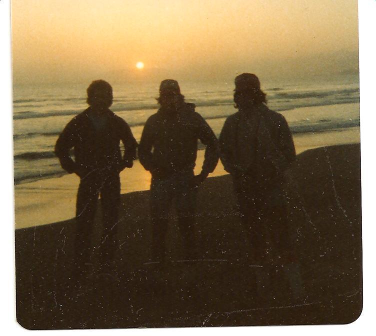
Briefly, I remember Pismo Beach, if only for the name of the place. I recall that Mark, Sue, and Debbie met us there, again after Orcutt. Since we got a late start from Orcutt and since Pismo was a nice place, we decided to call it a day and camp there. Our friends stayed with us until after sunset. See the photo below.
| Heart | 0 | Comment | 0 | Link |
May 11, 1981: From Pismo, the road turned inland. We passed through San Luis Obispo, a pretty town where it was warmer and sunnier than it was by the ocean. Then the road headed back to the cold, wet, and windy coast. Later, we arrived at Morro Bay. Once there, we left the highway and took a spin through town because some people we had spoken with, including a friendly State Farm Agent, recommended doing so. We cruised down Main Street, past the golf club, and ended up at the Embarcadero. We had lunch at a place called The Fish Bowl II. I had a bowl of clam chowder and a cup of hot tea to dispell the chill of the fog, the rain, and the constant Northwest wind.
After leaving Morro Bay, we passed through Cayucos and then through a ghost town called Harmony. A sign said the population was 18 residents. We took a short break at this pleasant little spot. When we moved on, the beautiful coastline beaches stretched out on our left all the way to the State Park, near San Simeon.

| Heart | 0 | Comment | 0 | Link |
While riding Northward, up the coast, the strong winds seemed to come out of the Northwest, bringing cold, clouds, and at times, rainy conditions. The coast is very hilly, as well. This was tough riding. Whenever we saw cyclists coming Southward, they were usually very friendly and seemed to be handling the same terrain with a lot less effort. We learned from a local (who said we were stupid for going North) that the overwhelming majority of cyclists who ride the West Coast start in the North and ride South. We didn't know any better, definitely didn't have the means to fly somewhere with our bikes, and really didn't care either. This was our adventure and we were playing the cards that were dealt to us. So far, we were doing fine.
From Harmony, we pedaled 4 miles further North, to Cambria, where we bought dinner fixings at a local market. Then, we rode 3 more miles Northward to our destination for the day. By the late afternoon of 5/11/81, we made it to the San Simeon State Park, where we camped on the beach. It lies roughly below a big cliff where the Hearst Castle is located. Some dry wood was located, enabling us to get a decent camp fire going, with some help from a German cyclist who was also camping there.
The three of us sat around the fire shooting the breeze about our respective trips. Among other topics, we also discussed the merits of German beer versus the currently available American varieties.
This was well before the craft beer era here in the USA.
The German fellow didn't think much of Budweiser or very many other American beers, for that matter. We were not very well-versed in German beers. However, it was all a moot point because we didn't have any beer of either German or American styles to do any taste testing in support the various points of view.
I don't think I ever fully appreciated his opinions until the craft beer movement came to America, many years later. Now, I rarely ever drink mass produced beer... when I drink beer (paraphrasing the Dos Equis commercial... which was not around in 1981).
I had planned to bathe in the ocean but it was so cold, both in and out of the water, that I simply retired to my tent, filthy as I was. My immediate goals were to keep warm by avoiding encroachment of the cold and dampness into my tent. Maybe the next day, we would find a warmer place to bathe.

| Heart | 0 | Comment | 0 | Link |
May 12, 1981: The next morning, we got a late start, due to waking up and finding everything completely soaked by the light rain that fell all night long. After getting things dried, as much as was possible, we started riding. Shortly thereafter, we stopped at a restaurant in San Simeon to warm up with coffee and muffins.
At Piedras Blancas, I had to replace a broken spoke and then true my wheel. The whole process took about 45 minutes. Shortly after resuming riding we entered the Big Sur region of the California Coast. My notes say we were in awe of the scenery that was all around us.
The winding and climbing road seemed to narrow significantly. We were accompanied by quite a few large recreational vehicles (RVs) that were having a tougher time navigating the road than were we. I remember feeling some empathy for the drivers, even though we were likely the more vulnerable parties out there.
The views of the ocean, from the cliffs we were climbing, were absolutely breathtaking. At times, sea lions coud be heard below. The terrain continued to be tough and the wind was ever present. Temperatures alternated between warm and cold whenever the clouds obscured the sun. Brief periods of rain would sometimes occur. But this was such beautiful country that I don't remember feeling despair at any time. We made it to the Plaskett Creek Campground at a relatively early, which allowed for setting up the tent in daylight and being able to rest a bit. Some photos of this day are below.

| Heart | 0 | Comment | 0 | Link |


My notes also relate that we met a fellow named Lloyd, who was biking up the coast to Seattle. He appeared to be approximately 60 years old. He started from San Bernardino and had made it this far, thus far.
On the morning of May 13, 1981, we began riding in a heavy and foggy mist. Everything I owned was completely soaked. Since it was so cold and damp, we stopped at a cafe in Pacific Valley Center, where we had coffee with 3 cyclists who were headed South. After having warmed up, we resumed our trek Northward and into the hills. We passed Lloyd, who was walking up the first one. He told us that he had a heart attack about 8 months ago and was doing this ride in an attempt to get back into shape and to strengthen his heart. We truly wished him well. We didn't see him after that, so I don't know how he fared. While I hope he made it and achieved his goal, I also know how demanding the subsequent hills became. If Lloyd made it through that area, he probably did a lot of walking.

The rainy and cold conditions persisted at least through the first half of the day. When CA-1 turned inland from the coast, there was a big and steep hill, near Loma Vista. Paul and I grunted to the top of it. The climb was followed by a long and fast descent. On the way down, we broke through the clouds and into some sun and warmth at Andrew Molera State Park. There, we took a break, each devoured 2 PB & J (Peanut Butter and Jelly) sandwiches, and then moved on.

The coastal road was winding and undulating, with 2 more huge hills to climb and descend. At Bixby Canyon, there was a tremendous view from a bridge where you look right down into the abyss. It was a long way down. About halfway down was the bumper of a car. The rest of the vehicle was at the bottom.
After that, we continued onward to Monterey, accompanied by more traffic than we had been seeing. We were anticipating getting to Carmel, where one of my favorite actors (at the time), Clint Eastwood, lived. At that time, he was at the top of his game and his movies were a staple. When we passed through Carmel, "The High Plains Drifter," who doubled as the Mayor of the town, was nowhere to be seen. Neither were any good or affordable (for us) accommodations.
We stopped at a little market, where I saw a newspaper with the headline, "POPE SHOT." That was shocking, especially after having been completely out of touch for the past several days. Earlier that year, President Reagan had been shot. I found out about it in a similarly delayed manner. Back then, there were no internet, cell phones, or computers. If you went on an excursion into the countryside, there was no way for anyone to get hold of you and you weren't seeing much news. I remember thinking at the time that I wanted to go back to Big Sur and never come back to civilization.
Judging from how things have developed and where we are today, I probably should have done that.
We continued on and finally found camping in Monterey. We had a note, speaking to our good characters, from a priest back in the San Fernando Valley (Fr. J). When we presented it to the priest at a local church, he allowed us to set up camp in a large field that was adjacent to the Rectory and the associated Parochial School. Paul went back into town to find us some food while I set up camp. While waiting for him to return, I was able to kick back and watch a magnificent sunset. Paul returned with some excellent take-out Chinese Food. Who needs those overpriced hotels and restaurants anyway? We had a great campsite, good food, and a beautiful sunset for entertainment.
After talking a bit and as evening came on, I crawled into the tent as the mosquitoes were discovering my presence. Safe and sound at last, sleep came quickly and heavily.
Today's ride: 180 miles (290 km)
Total: 362 miles (583 km)
| Rate this entry's writing | Heart | 1 |
| Comment on this entry | Comment | 0 |